Urbanization has transformed cities worldwide, but it has also introduced new environmental challenges. One of the most pressing issues is the phenomenon known as Urban Heat Islands (UHIs), where metropolitan areas experience significantly higher temperatures than surrounding rural regions. This rise in temperature is largely due to dense construction, reduced vegetation, and increased human activity. To combat this, a temperature mapping study has emerged as a critical tool, enabling cities to identify problem zones and develop strategies to reduce heat intensity.
At Eximia360 (www.eximia360.com), we specialize in delivering precise temperature mapping study services across Saudi Arabia, Jeddah, Dammam, and Riyadh, helping urban planners and organizations address heat management challenges effectively.
Understanding Urban Heat Islands
Urban Heat Islands form when natural landscapes are replaced with asphalt, concrete, and buildings that absorb and retain heat. These structures prevent heat from dissipating, causing temperatures to rise. The effect not only makes cities uncomfortable but also increases energy consumption, strains public health systems, and exacerbates climate change impacts.
By applying a comprehensive temperature mapping study, it becomes possible to analyze temperature variations across different urban sectors. This data provides insights into the most heat-affected areas, guiding solutions such as green spaces, reflective materials, and optimized building designs.

Why Temperature Mapping Study is Essential
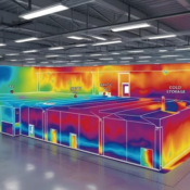
A temperature mapping study helps urban developers and policymakers visualize real-time heat data across cities. This analysis supports:
- Identifying Hotspots – Mapping pinpoints neighborhoods or districts with extreme heat, allowing authorities to focus mitigation strategies where they are needed most.
- Enhancing Energy Efficiency – Buildings in UHIs often consume more energy for cooling. Through temperature mapping study, energy-efficient retrofitting can be targeted.
- Public Health Protection – Heatwaves and rising temperatures put vulnerable populations at risk. Temperature data helps cities prepare health and safety interventions.
- Urban Planning Solutions – Planners can integrate findings from temperature mapping study to design more sustainable infrastructure and promote eco-friendly urban development.
At Eximia360, we ensure these studies are accurate and actionable, empowering local governments and businesses in Saudi Arabia, Jeddah, Dammam, and Riyadh with data-driven solutions.
Mitigation Strategies Guided by Temperature Mapping
The insights gained from temperature mapping study can lead to several heat-mitigation strategies:
- Urban Greening: Planting trees and creating green corridors reduces surface temperatures and improves air quality.
- Cool Roofing & Pavements: Reflective and heat-resistant materials help reduce the absorption of solar radiation.
- Smart City Integration: Data from temperature mapping study can be merged with smart city platforms to monitor and control environmental conditions in real-time.
- Water-Based Cooling Solutions: Fountains, artificial lakes, and water-sensitive designs can reduce the surrounding temperature effectively.
Eximia360’s expertise ensures that these solutions are guided by accurate data collected during every temperature mapping study we conduct.
Eximia360: Leading the Way in Temperature Mapping Study
At Eximia360, our mission is to make cities more resilient against climate change through reliable temperature mapping study services. With a strong presence in Saudi Arabia, Jeddah, Dammam, and Riyadh, we assist municipalities, commercial organizations, and developers in visualizing and addressing the challenges of urban heat.
Our advanced tools and methodologies help transform raw temperature data into meaningful insights. These insights not only mitigate the effects of UHIs but also pave the way for smarter, greener, and more livable cities.
Conclusion
The fight against Urban Heat Islands requires science, technology, and innovation. A temperature mapping study is more than just data collection—it is the foundation for sustainable urban planning and climate resilience. By leveraging this approach, cities can lower energy consumption, protect public health, and enhance the overall quality of urban living.
Eximia360 is proud to be at the forefront of this transformation, delivering specialized temperature mapping study services across Saudi Arabia, Jeddah, Dammam, and Riyadh. Together, we can build cities that are not only modern but also environmentally sustainable.
🌍 For more information, visit www.eximia360.com.


