

-
Precision Temperature Mapping for Pharmaceutical Transit Routes in Saudi Arabia

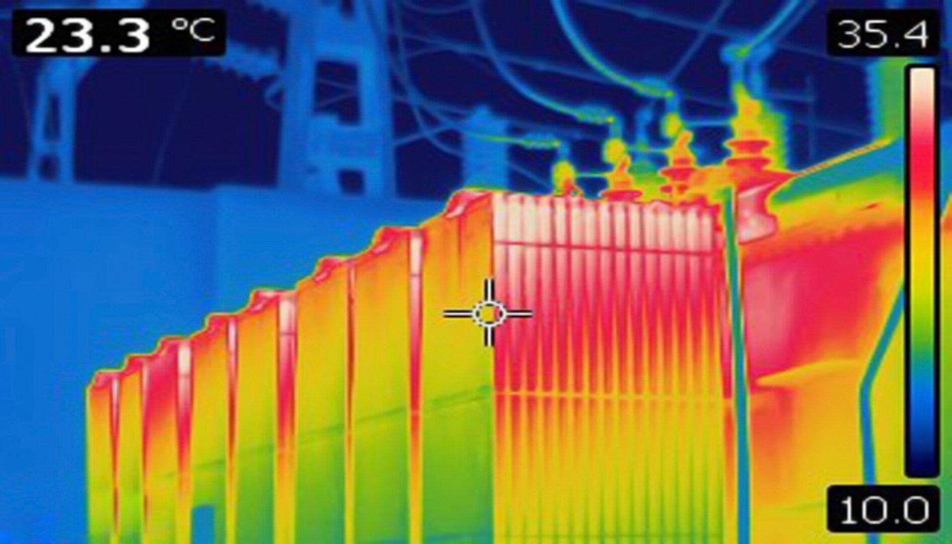
Ensuring the safe delivery of pharmaceuticals across long distances is one of the most critical responsibilities in the healthcare supply chain. In a vast and climate-intense region like Saudi Arabia, where temperatures can fluctuate drastically between regions such as Jeddah, Dammam, and Riyadh, maintaining the correct temperature during transport becomes an absolute priority. This is…
-
رسم الخرائط الحرارية من أجل لوجستيات مستدامة: تقليل البصمة الكربونية في الرياض والدمام دراسة توزيع درجات الحرارة

مع سعي المملكة العربية السعودية نحو مستقبل أكثر استدامة بما يتماشى مع رؤية 2030، أصبحت شركات الخدمات اللوجستية مطالبة بتبني ممارسات تقلل من التأثير البيئي لأنشطتها. ومن أهم الأدوات الحديثة لتحقيق هذا الهدف إجراء دراسة الـ دراسة توزيع درجات الحرارة التي تساهم بشكل مباشر في تحسين كفاءة الطاقة وتقليل هدر أنظمة التبريد (HVAC)، وبالتالي خفض…
-
Temperature Mapping for Sustainable Logistics: Reducing Carbon Footprints in Riyadh and Dammam

As Saudi Arabia moves toward a greener future aligned with Vision 2030, logistics companies are under increasing pressure to adopt sustainable practices. One of the most effective ways to reduce environmental impact is through optimizing temperature-controlled supply chains. A comprehensive temperature mapping study plays a crucial role in achieving these sustainability goals by improving energy…
-
The Hidden Cost of Ignoring Temperature Mapping in Saudi Supply Chains

In today’s highly regulated and quality-driven market, ignoring or delaying a temperature mapping study can be one of the most costly mistakes for businesses operating within Saudi Arabia’s supply chain ecosystem. Whether dealing with pharmaceuticals, vaccines, food products, or sensitive chemicals, maintaining strict temperature control is not optional—it is a compliance requirement and a business…
-
التكلفة الخفية لتجاهل رسم خريطة درجات الحرارة في سلاسل الإمداد السعودية دراسة توزيع درجات الحرارة

في بيئة الأعمال الحالية التي تتسم بارتفاع المعايير التنظيمية وزيادة التركيز على الجودة، أصبح تجاهل أو تأجيل دراسة رسم خريطة درجات الحرارة خطأً مكلفًا بشكل كبير، خصوصًا في سلاسل الإمداد داخل المملكة العربية السعودية. سواء كانت المنتجات أدوية، لقاحات، أغذية، أو مواد كيميائية حساسة، فإن التحكم الدقيق في درجات الحرارة يُعد ضرورة أساسية وليس خيارًا.…
-
تحليل ما بعد رسم خريطة درجات الحرارة: تحويل بيانات درجة الحرارة إلى تحسينات عملية لمستودعات المملكة العربية السعودية دراسة توزيع درجات الحرارة

تلعب دراسة رسم خريطة درجات الحرارة دورًا أساسيًا في ضمان أن تعمل مرافق التخزين في المملكة العربية السعودية ضمن نطاقات حرارية آمنة وفعّالة. ولكن القيمة الحقيقية لهذه الدراسة لا تكمن فقط في جمع البيانات، بل في مرحلة تحليل ما بعد رسم الخريطة، حيث يتم تحويل البيانات التي تم جمعها إلى رؤى عملية تساعد في تحسين…
-
Post-Mapping Analysis: Turning Temperature Data into Actionable Improvements for Saudi Warehouses
Temperature mapping study plays a crucial role in ensuring that storage facilities in Saudi Arabia operate within safe and efficient thermal conditions. However, the true value of temperature mapping lies not only in the data collection process but in the post-mapping analysis — the stage where collected data is transformed into meaningful insights and practical…
-
رسم خرائط المناخ الدقيق: فهم تباينات درجات الحرارة داخل مرافق التخزين الكبيرة في المملكة العربية السعودية دراسة توزيع درجات الحرارة

في عالم التخزين الحديث وإدارة المستودعات، يُعد الحفاظ على درجات حرارة مستقرة أمرًا ضروريًا للحفاظ على جودة المنتجات وكفاءة استهلاك الطاقة. ومع ذلك، حتى في أكثر المرافق تطورًا، نادرًا ما تكون درجات الحرارة موحدة في جميع المناطق. فهناك اختلافات طفيفة تُعرف باسم المناخات الدقيقة (Microclimates)، يمكن أن تُنشئ مناطق ساخنة وأخرى باردة غير مرئية تؤثر…
-
Microclimate Mapping: Understanding Temperature Variations Within Large Saudi Storage Facilities

In modern warehousing and industrial storage environments, maintaining consistent temperature conditions is critical for preserving product quality and optimizing energy performance. However, even in the most advanced facilities, temperature is rarely uniform. Subtle variations, known as microclimates, can create hidden hot and cold zones that impact both product stability and operational efficiency. This is where…
-
11 Advanced Practices for Continuous Temperature Mapping Study in Saudi Arabia

In the demanding climates of Saudi Arabia, especially in cities like Riyadh, Jeddah and Dammam, maintaining reliable cold-chain control is more than a one-time verification—it must be continuous. A properly executed temperature mapping study is the foundation, but to stay ahead, operations must adopt advanced practices that embed mapping into the regular rhythm of facility…
Search
Archive
Recent Posts
- 9 تطورات حديثة في دراسة رسم الخرائط الحرارية تؤثر على معايير المنشآت في السعودية دراسة توزيع درجات الحرارة
- 9 Emerging Temperature Mapping Developments Influencing Saudi Facility Standards

- 7 ممارسات في دراسة رسم الخرائط الحرارية تُبسّط الاستعداد للتدقيق في جدة والدمام دراسة توزيع درجات الحرارة

- 7 Temperature Mapping Practices That Simplify Audit Preparation in Jeddah and Dammam
- 8 سيناريوهات واقعية لدراسات خرائط الحرارة يجب أن يتوقعها كل مدير منشأة في السعودية دراسة توزيع درجات الحرارة

Gallery