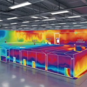
In the modern era of smart cities and sustainable development, data-driven decision-making is more important than ever. One of the key tools driving this transformation is Geographic Information Systems (GIS)—especially when paired with a temperature mapping study. At Eximia360, we specialize in integrating advanced GIS techniques with precise temperature mapping studies to deliver actionable insights that reshape urban environments and protect critical infrastructure.
Understanding Temperature Mapping Studies in Urban Contexts
A temperature mapping study involves collecting temperature data across various locations within a defined space, such as a city, industrial zone, warehouse, or transport vehicle. When applied at a city-wide level using GIS, these studies help stakeholders understand how heat distributes across urban landscapes and how it affects human health, energy efficiency, and infrastructure planning.
Urban areas, in particular, face unique challenges due to the Urban Heat Island (UHI) effect—where densely built environments retain more heat. By conducting a temperature mapping study with GIS tools, city planners and engineers can identify hotspots, cool zones, and thermally vulnerable areas, leading to better policy design and resource allocation.
How GIS Enhances Temperature Mapping Studies
At Eximia360, we combine temperature mapping study protocols with the analytical power of GIS to create high-resolution thermal maps. This process allows for spatial analysis, predictive modeling, and the development of smart solutions that go beyond basic temperature monitoring.
Key Benefits of Using GIS in Temperature Mapping:
- Data Visualization
GIS transforms raw data from a temperature mapping study into intuitive, interactive maps that can be layered with other datasets, such as population density, green space distribution, and building materials. - Predictive Analytics
Using GIS, we can forecast temperature trends over time and simulate the effects of urban planning decisions, such as increasing tree cover or altering road materials. - Resource Optimization
Cities can use GIS-based temperature mapping studies to deploy cooling resources like water stations, green roofs, or shaded bus stops more effectively. - Disaster Preparedness
Temperature mapping combined with GIS helps municipalities plan for heatwaves, guiding emergency services to areas of highest risk.

At Eximia360, we harness these capabilities to deliver precision-driven, scalable solutions through our project:
“The Role of GIS in Temperature Mapping: Turning Data into Urban Solutions.”
Learn more about our services at www.eximia360.com.
Real-World Applications
Our temperature mapping studies supported by GIS have been successfully used in various domains:
- Urban Planning: Identifying high-heat zones to drive zoning changes or support heat-mitigation infrastructure.
- Smart Transportation: Monitoring temperatures in transit corridors to improve passenger comfort and safety.
- Environmental Monitoring: Tracking microclimate behavior in parks, waterfronts, and public spaces.
- Industrial Facilities: Mapping temperature distribution in factories, warehouses, and data centers for optimal HVAC system design.
Whether you’re a municipality planning your next smart city project or a logistics company aiming to optimize cold-chain transport, Eximia360 provides customized GIS-integrated temperature mapping studies that empower your goals.
Why Choose Eximia360?
- Advanced GIS integration
- Certified expertise in temperature mapping studies
- Customized urban and industrial solutions
- Real-time and historical data analysis
- Compliance with international standards
Our team at Eximia360 stands at the intersection of technology and environmental science. With a commitment to innovation, we help cities and companies turn thermal data into strategic action through professional temperature mapping studies.
Let’s Build Smarter, Cooler Cities
As climate change continues to pose serious challenges for urban environments, the need for accurate, scalable, and data-rich solutions has never been more urgent. GIS-powered temperature mapping studies are no longer optional—they are essential tools in sustainable development.
Partner with Eximia360 to unlock the full potential of temperature mapping in your urban or industrial project.
Visit www.eximia360.com to discover how we’re turning temperature data into smarter urban solutions every day.


