
As urban populations continue to grow, the demand for efficient and resilient rail and metro systems becomes more critical. One of the most overlooked yet vital aspects of designing such systems is a temperature mapping study. This process helps infrastructure developers and engineers ensure that temperature-sensitive environments, equipment, and passenger areas operate safely and reliably under various conditions.
At Eximia360, we specialize in conducting professional temperature mapping studies across Saudi Arabia, including Jeddah, Dammam, Riyadh, and other major cities. Our services are tailored to meet the specific needs of rail and metro system developers, ensuring compliance, safety, and operational efficiency. Learn more at www.eximia360.com.
Why Temperature Mapping Matters in Transportation Infrastructure
Temperature mapping study involves the measurement and analysis of temperature variations within a defined space over a specific period. In the context of rail and metro systems, this applies to control rooms, server areas, passenger compartments, electrical cabinets, and storage facilities.
Fluctuations in temperature can affect the performance of sensitive electronics, signal systems, ventilation, and even structural components. Without accurate temperature mapping, these systems may fail under stress—particularly in regions with extreme climates like Saudi Arabia.
Designing for Resilience in Harsh Climates
Saudi Arabia’s high ambient temperatures and frequent sandstorms pose unique challenges for rail infrastructure. Components like communication systems, air conditioning units, power supplies, and track integrity can degrade quickly if not adequately protected. Temperature mapping study is essential to identify hot spots, airflow issues, and potential areas of thermal stress before they turn into operational failures.
Through advanced temperature mapping, Eximia360 helps engineers design cooling systems, insulation protocols, and sensor placements to mitigate these risks. This results in more robust, longer-lasting infrastructure.
Applications in Metro Stations and Train Cabins
Metro stations and train cabins require a consistent and comfortable temperature for passenger satisfaction. Uneven distribution of air conditioning can lead to discomfort, equipment breakdown, and increased energy costs. A temperature mapping study helps identify zones where airflow may be insufficient or temperatures deviate from the desired range.
In cities like Jeddah and Riyadh, where outside temperatures can soar beyond 45°C, maintaining an optimal internal environment is not just about comfort—it’s a necessity for health and safety. Eximia360’s precise temperature mapping services support the design of efficient HVAC systems and improve the overall commuter experience.
Impact on Energy Efficiency and Sustainability
Modern metro systems are expected to be energy-efficient and environmentally sustainable. However, poor thermal management leads to overuse of cooling systems and increased energy consumption. With a professional temperature mapping study, designers can optimize energy use by targeting problem areas and improving insulation.
This leads to significant cost savings and aligns with Saudi Arabia’s Vision 2030 goal of sustainable urban development. Eximia360 provides this crucial data, helping transportation authorities in Dammam, Riyadh, and Jeddah to design energy-smart rail solutions.
Regulatory Compliance and Safety
Many international and local standards now require temperature-controlled environments for critical infrastructure. By conducting a temperature mapping study, developers can ensure compliance with these regulations, reduce liability, and avoid costly penalties.
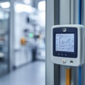
Eximia360’s expert team uses calibrated sensors and data loggers to deliver comprehensive reports that are audit-ready. We support organizations across Saudi Arabia in meeting both safety and compliance benchmarks.
Conclusion
As cities evolve and demand for reliable public transportation grows, the resilience of metro and rail systems becomes paramount. A thorough temperature mapping study is a foundational step in building infrastructure that performs under pressure and stands the test of time.
Eximia360 is proud to be a trusted partner for temperature mapping services in Saudi Arabia, offering customized solutions in Jeddah, Dammam, Riyadh, and beyond. Visit www.eximia360.com to learn how we can support your next transportation project.